All posts tagged Trails

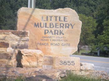
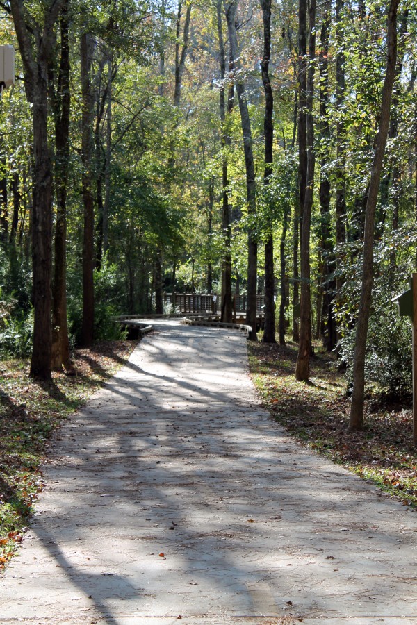
Trail Run – Little Mulberry Park Saturday May 21st at 9am

Little Mulberry Park - Entrance

Little Mulberry Park – foot trail

Fleet Fee of Johns Creek is doing a run THIS SATURDAY! The run starts at 9:00am at Little Mulberry Park. There are several different parking lots, so be sure to follow the directions provided below.

The run will be broken into both a beginner group and an advanced group. The beginner loop is going to consist of a 3 mile run along the Ravine Loop Trail. The trail is going to have decent elevation gains/losses and will force runners to focus on both running and hiking when necessary. The advanced loop extends closer to six miles and will traverse both the Ravine Loop and parts of the Fast Mulberry Trail.

There are four points that will be focused on during the run:
1. Map Reading: this is going to be necessary skill for our group runs going forward.
2.Trail Recognition: understanding how to handle different terrains as well as the ability to know where you are on the trail is essential.
3. GPS: The Fleet Feet team will spend a bit of time prior to the run discussing GPS on the trails and they will take the time after to answer any questions people have about different devices.
4. Running With a Partner: This is probably the most important thing to focus on as it instills good safety habits and makes the run more enjoyable.

Markers will be set up along the trail to inform runners of when to use their maps during the run. This is meant to be a lot of fun, but will also help reinforce necessary trail running skills.

Recommended Products:
Trail Running shoes, hydration belt or hand held water bottle, sweat wicking clothing, nutrition (i.e. gels or cliff bar), GPS device, and a phone if possible.

Address: 3855 Fence Road, Auburn,GA (note: the address listed brings you close to the park, if you use this plan on heading east on fence road once you reach the destination. The park will be on your left.

The page at Trimble Outdoors provides a bit of information about the trails at Little Mulberry including elevation, GPS coordinates, over 50 trail pictures and points of interest.

Share

FALL INTO SAFETY WITH NEW SIGNS AT THE PARKS!


Gwinnett County Parks and Recreation is dedicated to providing a safe and enjoyable environment for park patrons and fall is the perfect time to remind citizens to be safe and smart when visiting the many parks throughout the county. With the end of Daylight Savings time on November 7 comes cooler temperatures and shorter days, which means less daylight for your park adventures! In order to continue providing a safe and enjoyable environment, GCPR will be installing new Park Smart signs at various parks. The installation of these signs is in partnership with Gwinnett County Police Department, in an effort to reduce the risk of park patrons becoming victims of crime.

After attending crime prevention training and consultation with other departments around the state, members of the Gwinnett County Police department came up with the concept and design of these signs. The signs were funded with a crime prevention grant made to the police department. Eric Rooks, with the Gwinnett County Police department said: “In Gwinnett County, the majority of entering autos we investigate are the result of vehicles left unlocked.  These Park Smart signs will hopefully serve as a reminder to our citizens to lock their cars and to keep valuables out of sight.”

As always, GCPR stresses the importance of planning accordingly and paying attention to basic safety guidelines. All passive community and conservation parks, such as Harbins Park are open from sunrise to sunset. It is important to remember that trails are not lit, however GCPR does offer lighted walking tracks to meet the exercise needs of its citizens at 8 locations across the county. Lighted walking tracks are available at Bay Creek Park, Bethesda Park, Duncan Creek Park, Lenora Park, Peachtree Ridge Park, Shorty Howell Park, West Gwinnett Park and Rock Springs Park. Patrons are encouraged to check the website for up to date information, and pay special attention to park rules/signs.

With the days getting shorter, it is important to avoid being caught by darkness, and exit the park or return from your walk/hike prior to closing. GCPR values its partnership with the patrons and encourages the report of any safety concerns or suspicious activity.  Park patrons are asked to call 911 in case of emergency, otherwise they can call the Police non-emergency number, 770.513.5100.

Share

8 Multi-Purposed Trails (Paved and Soft Surface) for National Trails Day


Bogan Park Community Recreation Center
2723 North Bogan Road, Buford 30519
Park Hours: Sunrise to sunset unless posted otherwise
Two miles of trails

Dacula Park
205 Dacula Road, Dacula 30019
Dacula Activity Bldg., 2735 Old Auburn Ave., Dacula GA 30019
Hours: Sunrise until 11:00pm unless posted otherwise
1.75-mile paved, multi-purpose trail

George Pierce Park Community Recreation Center
55 Buford Highway, Suwanee 30024
Park Hours: Sunrise to 11:00pm unless posted otherwise
2.6-mile paved, multi-purpose trail • 1.2-mile soft surface trail

Harbins Park
2995 Luke Edwards Road, Dacula 30019
Hours: Sunrise to sunset unless posted otherwise
4.3-mile paved, multi-purpose trail
Soft surface trails for equestrian (7-mile), mountain biking (7-mile) and hiking (4.5-mile)

Ivy Creek Greenway
2020 Clean Water Drive, Buford GA 30519
near the corner of Buford Drive and Mall of Georgia Boulevard, Buford GA
1.3-mile paved, multi-purpose trail • 1.4-mile soft surface trail

Little Mulberry Park
Hours: Sunrise until sunset unless posted otherwise
Info & Rentals: 770.614.2060
Trail Info: 770.978.5270
5 miles of paved, multi-purpose and soft surface trails for equestrian and hiking

Settles Bridge Park
380 Johnson Road, Suwanee 30024 Hours: Sunrise until sunset unless posted otherwise
1.6-mile paved, multi-purpose trail • 2.9-mile soft surface trail

—————————————————————————–

Tribble Mill Park
2125 Tribble Mill Parkway, Lawrenceville 30045
(off of New Hope Road) Hours: Sunrise until sunset unless posted otherwise
3.4-mile paved, multi-purpose trail
• Soft trails for equestrian, mountain biking and hiking

Grayson
Take I-285, Exit 39 B, the Stone Mountain Freeway East towards Snellville and Athens for 16.3 miles to SR 84 (begin watching for it after crossing Scenic Highway (SR 124) in downtown Snellville). Turn left and travel 5.6 miles to a 4-way stop at New Hope Road. Turn right and travel 0.5, making a right on Tribble Mill Parkway. After entering the park turn left in the first parking lot and return to the trail.
Tribble Mill Park Trail
Tribble Mill Park Trail maps and directions

Directions to:
Tribble Mill Park Trail
Follows a paved loop trail around the east end of Ozora lake. Many unpaved paths join this trail for hiking and mountain biking opportunities

Share

McDaniel Farm Park


From Foresite Group

For this historical park project, Foresite Group (with offices in Norcross and the Southeast) worked with Gwinnett County Parks and Recreation to design and permit this beautiful site. Located in Duluth, Georgia, McDaniel Farm Park is a 128 acre park, a former cotton farm, that has been restored to depict a typical 1930s subsistence farm in Gwinnett County. This park includes 2.5 miles of connecting, paved multi-purpose trails, a picnic pavilion and a large informal play area and was completed in 2005.

From Trails.com

McDaniel Farm Park is built around a subsistence farm similar to many of the farms in the area. In addition to the asphalt trail, there is a heritage display that is interpreted by docents on Tuesday, Thursday, and Saturday. When people think of antebellum Georgia, they picture the massive cotton plantations of the coast. In the Atlanta area, however, most agriculture before the Civil War was subsistence farming, raising enough corn and wheat to meet only the needs of the family. Read more and found out about the trails at trails.com

Park & Trails Info: 770.822.8840
Historic Info & Rentals: 770.904.3500
mcdanielfarm@gwinnettcounty.com

Park hours are from sunrise until sunset unless otherwise posted.

Office Hours: F, SA 10:00am-4:00pm

Description

Acres: 134

  • McDaniel Farm is restored to depict a typical 1930?s farm in Gwinnett County
  • Furnished farmhouse
  • Barn
  • Blacksmith shed
  • Carriage house
  • Tenant house
  • Tours
  • Pavilion
  • 3-miles of paved multi-purpose and soft surface trails
  • Grill
  • Restrooms

Parks & Recreation Master Plan Documents

McDaniel Farm Park

Mc Daniel Farm Park

www.gwinnettcounty.com

3251 McDaniel Road
Duluth, GA 30096-4605
(770) 814-4920
Get directions

Share